News
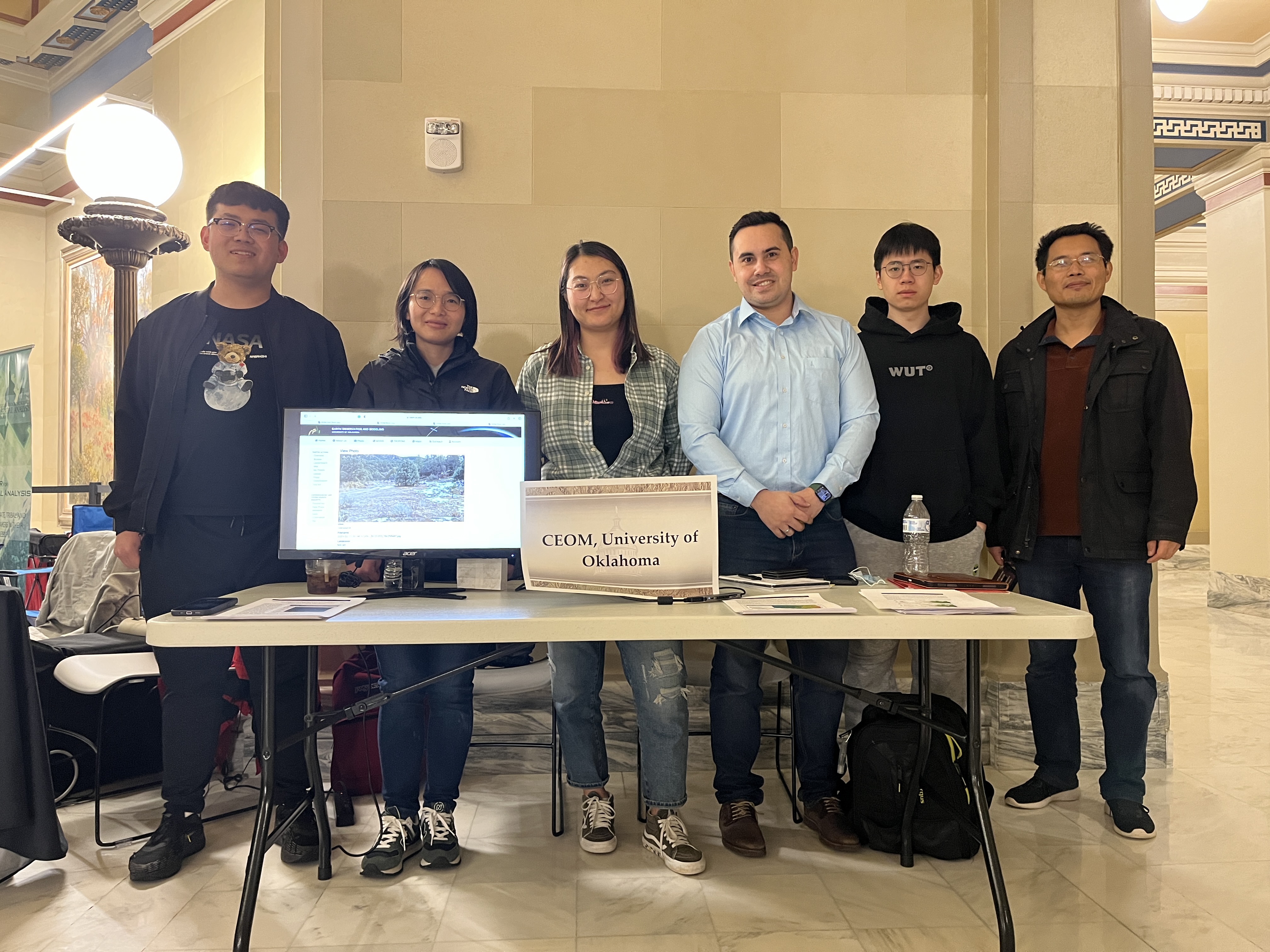
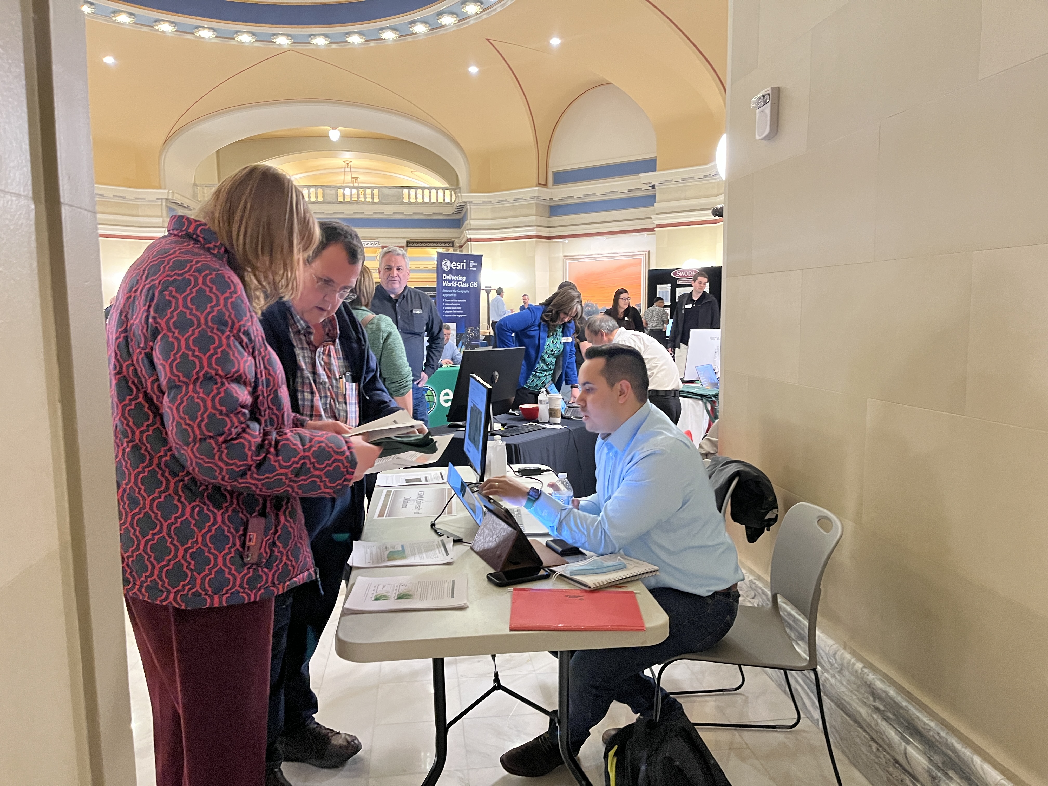
CEOM participates the 29th Annual DIS Day at Oklahoma's Capitol
March 9, 2023
Six CEOM members (Yuanwei Qin, Jorge Celis, Chenchen Zhang, Yuan Yao, Cheng Meng, and Li Pan) participated in the 29th GIS Day at Oklahoma's Capitol on March 9, 2023. The CEOM team presented the recent progress in land cover/land use change and GPP modeling in Oklahoma. The CEOM team also taught people how to use the free tools available on the CEOM website (https://www.ceom.ou.edu) to explore land cover change, land surface temperature change, and field photos from around the world. GIS Day at the Capitol is a unique opportunity for the public and private sectors to highlight the uses of GIS and to showcase how the technology is being used as a decision-making tool throughout the state of Oklahoma.
Images
Kenneth & Joye Harwell Endowed Scholarship to Jorge A. Celis Rodriguez and Chenchen Zhang
April 22, 2022
Jorge A. Celis Rodriguez, a second-year Ph.D. student, and Chenchen Zhang, a first-year Ph.D. student in CEOM were awarded the Kenneth & Joye Harwell Endowed Scholarship. The Kenneth & Joye Harwell Endowed Scholarship is to provide financial assistance to graduate students who are in good academic standing.
Images
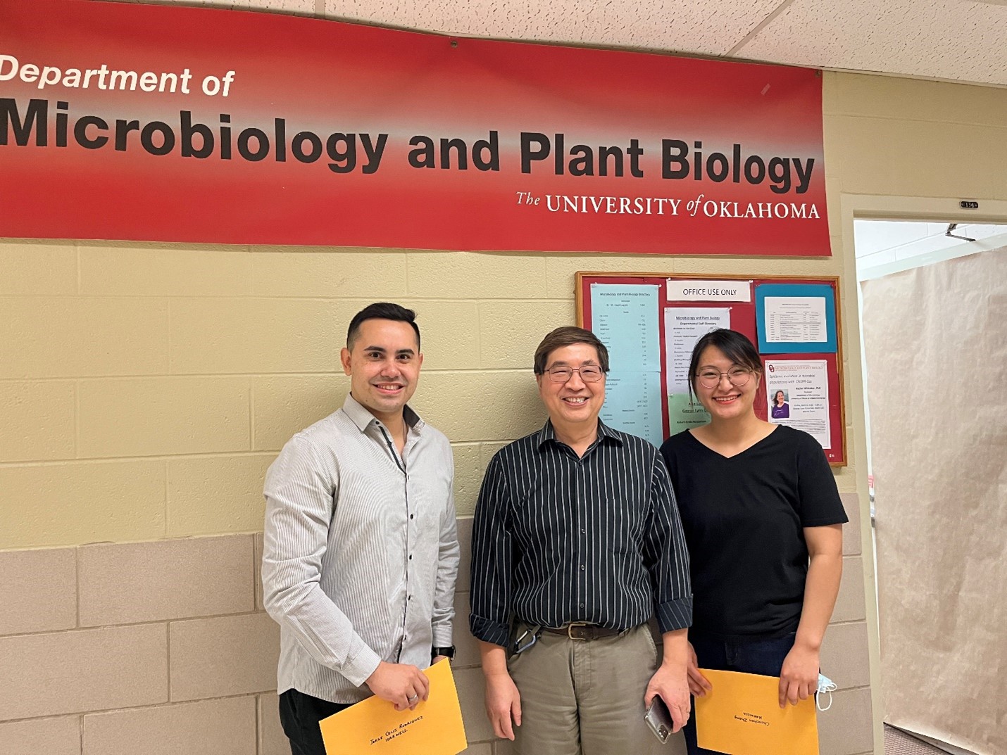
Jorge and Chenchen
NASA selected the Geostationary Carbon Cycle Observatory (GeoCARB) mission
March 8, 2017
On December 6, 2016, NASA announced its selection for the Geostationary Carbon Cycle Observatory (GeoCARB) mission, led by Prof. Berrien Moore III of the University of Oklahoma. The primary goal of this mission is to monitor plant health and vegetation stress through solar-induced chlorophyll fluorescence (SIF), and to probe the natural sources, sinks, and exchange processes that control carbon dioxide, carbon monoxide, and methane in the atmosphere. Total NASA funding for the mission over the next five years (2017 – 2022) will be $166 million, which includes initial development, launch of the mission on a commercial communication satellite, and data analysis. The mission partners include the Lockheed Martin Advanced Technology Center in Palo Alto, California; SES Government Solutions Company in Reston, Virginia; the Colorado State University in Fort Collins, Colorado; and NASA’s Ames Research Center in Moffett Field, California, Goddard Space Flight Center in Greenbelt, Maryland, and Jet Propulsion Laboratory in Pasadena, California. At the University of Oklahoma, several researchers from the Earth Observation and Modeling Facility, Xiangming Xiao, Yao Zhang, Geli Zhang and Yuanwei Qin have been involved in the proposal development, and will work for the project implementation with specific focus on application requirements of the GeoCARB mission, including agricultural drought and productivity models.
Images
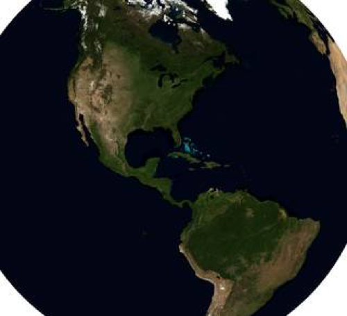
Geostationary Carbon Cycle Observatory(GeoCARB) mission
OU Research Team Investigates Microbe-Climate Interactions In Greenhouse Gas Emissions from Oklahoma Grasslands and Croplands
April 21, 2016
Norman, Okla.—A University of Oklahoma research team will analyze microbe-climate interactions in greenhouse gases (CO2, CH4 and N2O) from grasslands and croplands in Oklahoma. The four-year, $3 million project funded by the U.S. Department of Agriculture’s National Institute of Food and Agriculture will provide an understanding of microbe-climate interactions, plus educational opportunities for educators, students and professionals. Xiangming Xiao, Boris Wawrik, Jizhong Zhou and Zhili He, professors in the Department of Microbiology and Plant Biology, OU College of Arts and Sciences, will develop and apply a multi-scale and integrated observation and modeling framework to address the major scientific questions relevant to microbe-climate interactions, with team members Jeffrey Basara, Oklahoma Climatological Survey and OU School of Meteorlogy; Linda Atkinson, OU K20 Center; Jean Steiner, USDA Agriculture Research Service Grazinglands Research Laboratory; Ann Marshall, BlueSTEM AgriLearning Center; and Steve Frolking and Jia Deng, University of New Hampshire. Microbes play a key role in modulating greenhouse gases emissions in agro-ecosystems. Few studies have investigated microbe-climate interactions across multiple spatial (laboratory, plot, ecosystem and landscape) and temporal (hourly, daily, seasonally and inter-annually) scales under livestock grazing and manure applications. The overall research goal of this project is to improve understanding of and model microbe-climate interactions in grazed lands and manure-applied croplands across various spatial-temporal scales. The supporting research objectives of this project are to (1) quantify the role of microbial community diversity, structure and function on greenhouse gas emissions from grasslands and winter wheat croplands; (2) develop and improve the microbial processes sub-model to estimate greenhouse gas emissions; and (3) apply the plant-soil-microbe models to estimate greenhouse gas emissions across landscape and watershed scales. The education component of this project will include a multi-level and cross-disciplinary education framework to address the major education questions relevant to the human capacity for agriculture. The overall goal is to improve and expand the human capacity in understanding the results from agricultural research, using relevant results for agricultural decision making, and participating in agriculture research and education. The educational initiative will provide a deeper understanding of the contributions of integrated science to the research base and its practical application in our lives.
Images
OU Research Team Investigates Microbe-Climate Interactions In Greenhouse Gas Emissions from Oklahoma
Robberson Travel Grant to Yao Zhang
Jan. 28, 2016
Yao Zhang, second year Ph.D. student was awarded a Robberson Travel Grant in the amount of $1000 to support the attendance of 2015 AGU Fall Meeting in San Francisco, CA. Yao gave an oral presentation entitled ‘Vegetation and canopy control of GPP during drought and heatwave’ and a poster presentation entitled ‘Modelling gross primary production in North America with MODIS images and reanalysis climate data’. AGU Fall Meeting is the largest Earth and space science meeting in the world. It provides a great opportunity to network and make connections with other scientist and researchers in the field.
Graduate College Robberson Travel Grant to Yuting Zhou
Dec. 21, 2015
Yuting Zhou, Ph. D. candidate in EOMF was awarded a Robberson Conference Presentation & Creative Exhibition Travel Grant in the amount of $824. This award is in support of travel to attend the 2015 AGU Fall Meeting. The purpose of the Robberson Conference Presentation and Creative Exhibition Travel Grant is to provide financial assistance to academically outstanding students who are presenting significant research information or creative activity. AGU Fall Meeting is the largest Earth and space science meeting in the world. It provides a great opportunity to network and make connections with other scientist and researchers in the field.
2015 OU GIS Day Expo and 2015 Oklahoma Workshop on Remote Sensing Technology and Applications
Sept. 1, 2015
The 2015 OU GIS Day Expo will be held November 17, 2015 from 10am to 3pm in the Molly Shi Boren Ballroom at the Oklahoma Memorial Union, 900 Asp Ave. Norman, OK 7309 Registration and more information coming soon. For more information or accommodation on the basis of disability contact Melissa Scott at (405) 325-4871 or mscott@ou.edu .(There is also a flier attached for the event.) The 2015 Oklahoma Workshop on Remote Sensing Technology and Applications will take place November 16th, 2015 9:30am – 5:00pm at the University of Oklahoma, Four Partners Place room 3065 located at 301 David L. Boren Blvd. in Norman Oklahoma. More information and registration coming soon at http://www.eomf.ou.edu/workshops/ . For more information or accommodation on the basis of disability contact Melissa Scott at (405) 325-4871 or mscott@ou.edu .(There is also a flier attached for the event.)
EOMF participates in a 2-year NOAA project "Engaging citizen scientists to ground-truth the U.S. Drought Monitor"
Aug. 1, 2015
The EOMF is one of four partners who work together to implement this 2-year NOAA SARP project (2015-2017). These four partners are the NOAA-funded Southern Climate Impacts Planning Program (SCIPP) at the University of Oklahoma, the CoCoRaHS citizen science group at the Colorado State University, iSeeChange media company, and the Earth Observation and Modeling Facility (EOMF) at the University of Oklahoma. The project aims to (1) establish a consistent standard photo-taking protocol for field photos library, (2) improve the user interface and experience for photo uploading and editing in smartphone app and data portal by citizens, (3) develop a visual drought scale from the field photos documenting the landscapes, and (3) calibrate the drought scale from field photos with the U.S. Drought Monitor (USDM) indices. This project will help establish a national capacity that uses visual observations for drought impact assessment.
The Android App "Field Photo" is now available for citizen science and community remote sensing
Feb. 26, 2014
In an effort to support citizen science and community remote sensing, EOM developed and released the first android App "Field Photo", it is freely available to the public. See http://www.eomf.ou.edu/photos/ for more information and download it from Google Play Store https://play.google.com/store/apps/details?id=com.eomf . The Field Photo App allows students, researchers and citizens to take photos during field trips, geotag them and add metadata and field notes to the photos. The field photos are then uploaded to the Global Geo-Referenced Field Photo Library at the University of Oklahoma, where people share, visualize and archive field photos that document land use and land cover change, flood, drought, fire, and so on. These photos and associated thematic databases are also used to support satellite image analyses for monitoring the dynamics of Planet Earth, where now more than seven billions of people live. The integration of mobile phone, Geo-Referenced Field Photo Library and satellite images allows us to socialize the pixels in the images.
Images
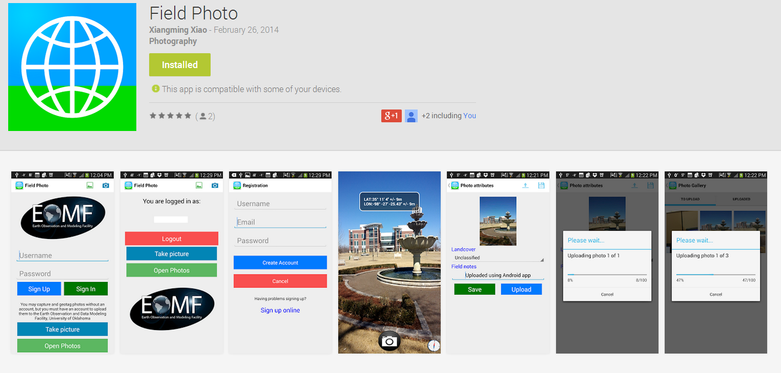
Screenshot of google play store page to download Field Photo app
Eight EOMF members attended the AGU 2013 meeting in San Francisco
Dec. 21, 2013
With the supports from the USDA interdisciplinary project “Resilience and vulnerability of beef cattle production in the Southern Great Plains under changing climate, land use and markets” and the NASA LCLUC project “Quantifying changes in agricultural intensification, expansion and gross primary production in monsoon Asia during 2000-2010”, eight EOMF members (Pradeep Wagle, Yuanwei Qin, Nyambayar Batbayar, Michael Angelo Menarguez, Cui Jin, Jie Wang, Yuting Zhou, and Jinwei Dong) attended the AGU 2013 meeting in San Francisco from December 8-13, 2013. Three posters were presented from the EOMF in the meeting, showing the recent progress in the LCLUC and water quality remote sensing fields in the EOMF. Dr. Jinwei Dong gave the poster presentation titled “Improved estimation of forest area in tropical Africa through ALOS/PALSAR 50-m orthorectified mosaic images” (B23D-0580). Ms. Cui Jin presented the poster titled “Mapping paddy rice using multi-temporal Landsat imagery in the Sanjiang Plain, Northeast China” (B41A-0389); and Ms. Jie Wang talked about “Detecting Chlorophyll and Phycocyanin in Lake Texoma Using in Situ Photo from GPS Digital Camera and Landsat 8 OLI Imagery” (H43G-1546) on behalf of Dr. Jinheng Zhang. For detailed information about the presentations, please check the column "About US"--->"Publication"--->"Presentations" in this website later.
Images
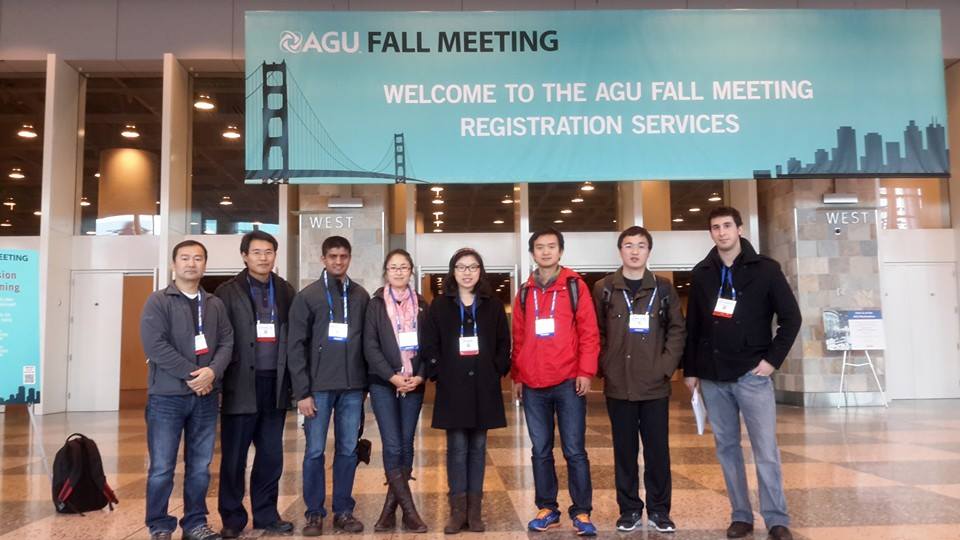
Eight EOMF members attended the AGU 2013 meeting in San Francisco
The iPhone App "Field Photo" is now available for citizen science and community remote sensing
Oct. 20, 2013
In an effort to support citizen science and community remote sensing, EOM developed and released the first iPhone App "Field Photo", it is freely available to the public. See http://www.eomf.ou.edu/photos/ for more information and download it from Apple Store https://itunes.apple.com/us/app/field-photo/id717945301. The Field Photo App allows students, researchers and citizens to take photos during field trips, geotag them and add metadata and field notes to the photos. The field photos are then uploaded to the Global Geo-Referenced Field Photo Library at the University of Oklahoma, where people share, visualize and archive field photos that document land use and land cover change, flood, drought, fire, and so on. These photos and associated thematic databases are also used to support satellite image analyses for monitoring the dynamics of Planet Earth, where now more than seven billions of people live. The integration of mobile phone, Geo-Referenced Field Photo Library and satellite images allows us to socialize the pixels in the images.
Images
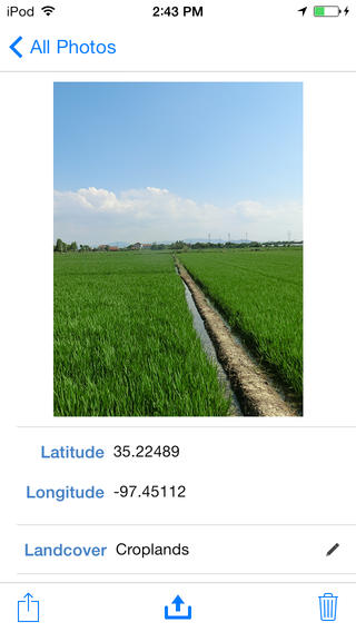
Screenshot from iPhone app
EOMF participated in a 5-year project that studies deforestation and rodent-borne diseases in South America
Oct. 1, 2013
The EOMF is one member of a multi-institution and international team for an interdisciplinary project "Effects of anthropogenic habitat perturbation on rodent population dynamics and risk of rodent-borne diseases". This 5-year project (2013-2018) will be carried out in Peru, Bolivia and Paraguay through close collaboration with a number of local institutions and researchers in these three countries. Institutional partners in USA are (1) Tulane School of Public Health and Tropical Medicine, (2) University of Kansas, and (3) University of Oklahoma. The EOMF team will use geospatial technologies to characterize land use and land cover changes, and provide the resultant geospatial data to support spatial models in the project. The project is funded by the Inter-American Institute for Global Change Research (IAI) Collaborative Research Network (CRN3) program.
New technologies help to track wild bird migrations from Mongolia
Sept. 8, 2013
As part of the EOMF’s effort to study the highly pathogenic avian influenza H5N1 virus circulation in migratory wild bird populations across flyways, we use a number of new technologies to study bird migration and connectivity between wintering and breeding sites. In summer of 2013, Nyambayar Batbayar, a PhD student, conducted field studies in Mongolia and deployed a number of geo-light loggers on Barn Swallows and White-throated Bushchats, and cellular tracking and satellite transmitters on White-naped Cranes. On these projects, he is collaborating with Oklahoma Biological Survey, Oriental Bird Club, International Crane Foundation, US Forest Service, Poyang Lake Nature Reserve in China, Mongolian Academy of Sciences, and Wildlife Science and Conservation Center of Mongolia.
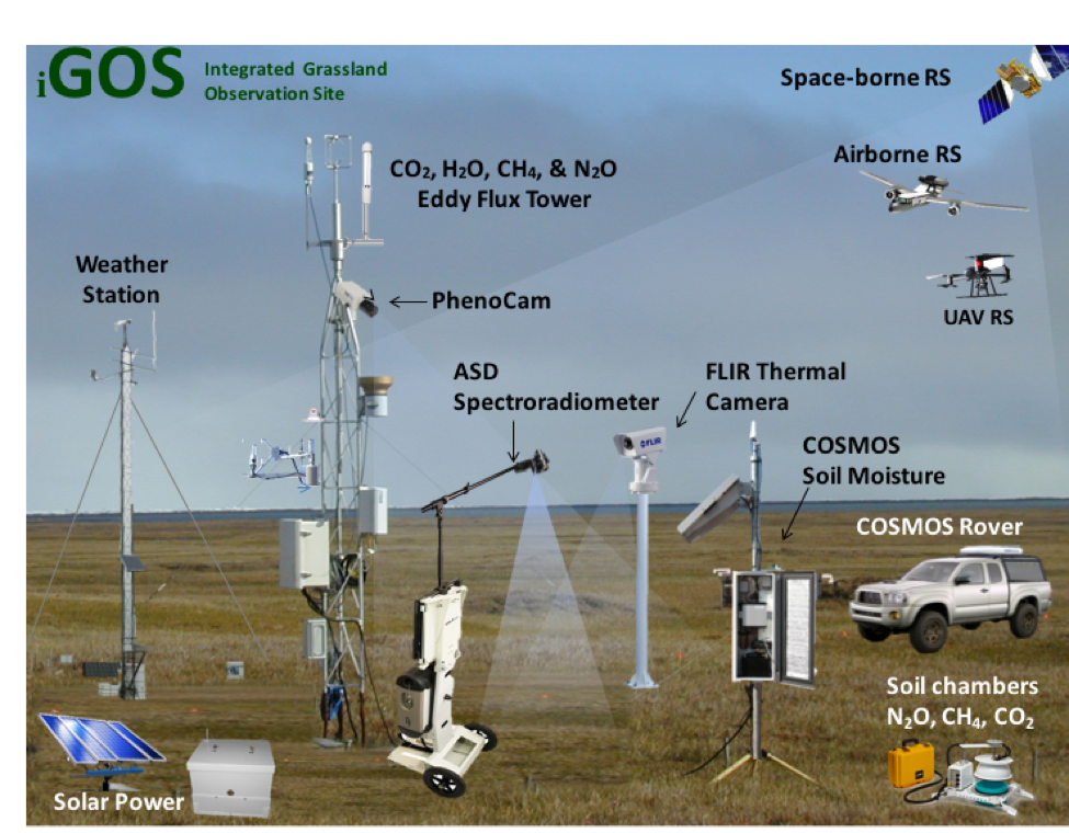
Two Integrated Grassland Observation Sites (iGOS) started to operate at El Reno, Oklahoma
Sept. 1, 2013
As part of a collaborative effort between OU Department of Microbiology and Plant Biology (DMPB), OU School of Meteorology (SoM), the Oklahoma Climatological Survey (OCS), and the USDA ARS Grazinglands Research Laboratory (GRL), two integrated grassland observation sites (iGOS) have recently been established at the USDA ARS Grazinglands Research Laboratory, EL Reno, Oklahoma. One iGOS site sits on native grasslands, which has never been cultivated, and the other iGOS site sits on improved pasturelands. Each site is equipped with an advanced eddy covariance tower system for measuring energy, carbon, water and methane fluxes between the land surface and the atmosphere, a Phenocam to track plant phenology, and a COSMOS instrument to measure soil moisture at the landscape scale. In addition, hyperspectral, multispectral and thermal remote sensing measurements are routinely carried out at the sites. The iGOS sites are also co-located with the Oklahoma Mesonet El Reno site. This collaborative project has been supported by the NSF EPSCoR projects and USDA NIFA project and will carry out multiple year observations at the iGOS sites (up to 5 years with current NSF and USDA grants, and subsequently as part of the Southern Plains Long-term Agroecosystem Research Network). For more information about the iGOS sites, please contact Dr. Jeffrey Basara (jbasara@ou.edu), Dr. Jean Steiner (jean.steiner@ars.usda.gov), and Dr. Xiangming Xiao (xiangming.xiao@ou.edu).
The EOMF received NIH fund to study highly pathogenic avian influenza H5N1 subtype in China and Thailand
Aug. 1, 2013
The EOMF is part of a multi-institution and international team that received $1.9 million from the National Institute of Allergy and Infectious Diseases (NIAID), National Institutes of Health for an interdisciplinary project "Transmission dynamics and spillover of avian influenza under changing agriculture intensification and landscape" (7/23/2013 – 6/30/2017). Major institutional partners of the project are (1) Free University of Brussels, Belgium, (2) University of Warwick, UK, (3) Chinese Center for Disease Control and Prevention, Beijing, China, (4) US Geological Survey, California, USA, and (5) Food and Agriculture Organization of the United Nations, Rome, Italy. The project will carry out field work in Poyang Lake, Chin and Thailand.[PDF]
The 5th International Workshop on Community-based Data Synthesis, Analysis and Modeling of Highly Pathogenic Avian Influenza (May 27 - 31, 2013, Hanoi, Vietnam)
July 1, 2013
Dr. Xiao travelled to Hanoi, Vietnam and co-chaired the 5th workshop with Dr. Scott Newman from the Food and Agriculture Organization (FAO) of the United Nations. This workshop was co-sponsored by the National Institutes of Health (NIH) Fogarty International Center (FIC), the Food and Agriculture Organization (FAO) of the United Nations, the University of Oklahoma (OU) and the Department of Animal Health (DAH) of the Vietnamese Ministry of Agriculture and Rural Development. The FAO Country Office in Vietnam and the Department of Animal Production and Health provided local logistical support for the workshop. It was composed of a 2-day scientific meeting in Hanoi, Vietnam and a 3-day field trip in the Red River Delta, Vietnam, where H5N1 outbreaks have persisted over years and where there are frequent trade movements in poultry and wildlife between northern Vietnam and Southern China.
The EOMF received NSF fund to study socio-ecological systems in Oklahoma, USA
July 1, 2013
The EOMF is part of a multi-institution team that received $20 millions from National Science Foundation for an interdisciplinary project “Adapting socio-ecological systems to increased climate variability” (6/1/2013 – 5/31/2018). Major institutional partners of the project are Oklahoma State University, the University of Oklahoma, the Samuel R. Noble Foundation, and the University of Tulsa.
The EOMF received USDA fund to study of the effect of weather and climate variability on beef cattle production systems in the Southern Great Plains, USA
May 10, 2013
The EOMF is part of a multi-institution team that received US$9.6 million from the USDA for an interdisciplinary project “Resilience and vulnerability of beef cattle production in the Southern Great Plains under changing climate, land use and markets” (2/15/2013 – 2/14/2018). Other partners of the project team include Oklahoma State University, Kansas State University, Texas Tarleton State University, the Samuel R. Noble Foundation, and two USDA ARS laboratories.